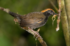
Rufous-capped Antthrush

Rufous-capped Antthrush

Formicarius colma

Silhouette: Abraão B. Leite · PhyloPic

LCLeast ConcernNTVUENCR
Daily sighting probability <5% · Rare
at Amacayacu National Natural Park

In 3 days ~10% in a week ~20%

19 Verified sightings at Amacayacu National Natural Park From 2019 to 2026
670 In all 8 parks
September Best month
☀️ Diurnal When it's spotted

About the Rufous-capped Antthrush

The rufous-capped antthrush (Formicarius colma) is a small species of bird in the family Formicariidae located in the order Passeriformes. It is considered to be uncommon but widespread, found in Bolivia, Brazil, Colombia, Ecuador, French Guiana, Guyana, Peru, Suriname, and Venezuela.

The rufous-capped antthrush is typically found inhabiting the shady floor of tall, humid forests on solid ground, and is occasionally spotted in transitional forests (várzea) and savanna forests (Suriname). The rufous-capped antthrush was first described by the French polymath Georges-Louis Leclerc, Comte de Buffon in his 1779 journal Histoire Naturelle des Oiseaux (Natural History, General and Particular, with a Description of the King's Cabinet) from a specimen collected in Cayenne, French Guiana and was further engraved by François-Nicolas Martinet in the Planches Enluminées D'Histoire Naturelle (Illuminated Planks of Natural History) which was produced under the supervision of Edme-Louis Daubenton to accompany Buffon's text. Neither Buffon's description nor Martinet's drawing included a scientific name, however, Dutch naturalist Pieter Boddaert coined the binomial name... Wikipedia →

Sounds

Call0:04

French Guiana · 2024

© Tristan Guillebot de Nerville · XC1174412 · CC BY-NC-SA 4.0

Song0:18

Brazil · 2024

© Augusto Matheus dos Santos · XC942589 · CC BY-NC-SA 4.0

Canto0:06

Brazil · 2014

© Caio Brito · XC427380 · CC BY-NC-SA 4.0

Global Distribution

Parks Where Found

# Park Country Daily sighting probability
1 Tambopata National Reserve 🇵🇪 Peru
~10%
2 Brownsberg Nature Park 🇸🇷 Suriname
~10%
3 Serra dos Órgãos National Park 🇧🇷 Brazil
~10%
4 Amacayacu National Natural Park 🇨🇴 Colombia
<5%
5 Manu National Park 🇵🇪 Peru
<5%
6 Anavilhanas National Park 🇧🇷 Brazil
<5%
7 Yasuní National Park 🇪🇨 Ecuador
<5%
8 Itatiaia National Park 🇧🇷 Brazil
<5%

Before you go

What are the chances of seeing a Rufous-capped Antthrush in Amacayacu National Natural Park?

Rare

Under 5% of wildlife watchers report a Rufous-capped Antthrush sighting in Amacayacu National Natural Park on a given day, based on 19 verified sightings from GBIF citizen-science data from 2019 to 2026. It is the 336th most-seen of the 436 birds we can rate there. Over three days the chance rises to about 10%, and over a week to about 20%, if each day is a fresh chance.

When is the best time to see a Rufous-capped Antthrush in Amacayacu National Natural Park?

September and October

In those months about 10% of wildlife watchers report a Rufous-capped Antthrush in Amacayacu National Natural Park on a given day, against under 5% in November to August, the lowest months.

What time of day is best to see a Rufous-capped Antthrush?

Between 7 and 10 am

Across all the parks we cover, that three-hour window holds the most Rufous-capped Antthrush sightings with a recorded time, and about 9 in 10 of them come between 6 am and 6 pm: it is a daytime animal.

Which relatives of the Rufous-capped Antthrush live in Amacayacu National Natural Park?

Same order: Passeriformes

The closest relatives of the Rufous-capped Antthrush that you can see in Amacayacu National Natural Park (order Passeriformes, Perching Birds) are Russet-backed Oropendola (about 70%), Yellow-rumped Cacique (about 60%) and Silver-beaked Tanager (about 50%), with each one's daily chance of a sighting.

Where does the Rufous-capped Antthrush sighting chance come from?

GBIF citizen-science records

It is estimated from how often the Rufous-capped Antthrush is recorded against all the birds logged in Amacayacu National Natural Park (19 verified sightings from 2019 to 2026), calibrated against known sighting rates. Figures are rounded to the nearest 10% because citizen-science data supports honest approximations, not decimals, and months with records from fewer than five people show "—". How it works.

← Back to Amacayacu National Natural Park